thunderstorms
 The most usual scenario that causes a thunderstorm is when cold air collides with warm, unstable air and violently pushes up the warm air. We often hear this described on the news as a "cold front." The most usual scenario that causes a thunderstorm is when cold air collides with warm, unstable air and violently pushes up the warm air. We often hear this described on the news as a "cold front."
Ask anyone “What is a thunderstorm?” and you will usually get the answer, “a storm that has thunder and lightning.” For most of us, that’s all we think we need to know. However, it helps to understand how a thunderstorm forms, so we can be better prepared before one occurs. For a thunderstorm to form, the air needs to be unstable, so it can be lifted easily. There needs to be a lifting mechanism and there needs to be a good amount of moisture (water vapor) in the air. Let’s take a closer look. Air is held to the Earth by gravity. The majority of air is in the first two layers of the atmosphere. The layer closest to Earth, called the Troposphere, is where weather occurs. Weather is caused by the uneven heating of the Earth. You will learn more about this concept in the summer. Uneven heating is the CSEP Science Concept for August 2019. So, without getting into many particulars…the sun’s rays heat the surface of the earth unevenly and the surface of the earth unevenly heats the air above it. This results in warmer patches of air and colder patches of air. When these “air patches (air masses)” collide, they don’t mix. When air is warm, it is less dense (heavy) and can easily be pushed up by colder, denser air. Most people normally think of this as “warm air rising.” The air is unstable and doesn’t want to stay close to the Earth. Sometimes when the warm air collides with the cold air, it is not forcibly pushed up, but simply slides above the cold air. This last situation is called a warm front and usually does not cause storms, but rather a steady rain. The Sun also heats surface water to the point of evaporation (change from a liquid to a gas). The resulting water vapor becomes part of the “air.” When the warm air rises, it carries the water vapor with it. At some point, as the air moves further away from the warm earth, the air cools. The water vapor in the air also cools. If the water vapor cools enough, it condenses (changes from a gas to a liquid) into little droplets of water. When enough droplets occur in one location, we see it as a cloud. When this entire process happens again and again and goes higher and higher into the Troposphere, big tall clouds can form. These big tall clouds are called cumulonimbus clouds. Inside the cumulonimbus cloud, electrical charges build up. The positive charges stay at the top of the cloud. The negative charges move to the bottom of the cloud. 
The cumulonimbus cloud is an impressive sight. It is a vertically growing cloud that is shaped like an anvil. The reason it has the flattened top is because the cloud has reached the Tropopause. The Tropopause is the division between the Troposphere and Stratosphere, the first and second layers of the atmosphere.
|
At some point a “spark” occurs between the positive and negative charges. This spark is lightning within the cloud. Sometimes this spark occurs between clouds. This is cloud to cloud lightning. And very often, the spark occurs between the negative charges in the lower portion of the cloud and the positive charges that surround things sticking up out of the Earth’s surface. This is cloud to ground lightning.

Within the cloud lightning.
(https://cloudatlas.wmo.int/lightning-cloud-discharges.html /Matthew Clark)

Cloud to cloud lightning; often called sheet lightning.
(http://www.pxleyes.com/photography-picture/4f5e9d996db6d/Sheet-lightning.html )
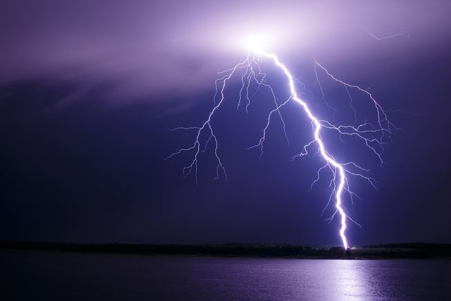
Cloud to ground lightning!
(Photo: Kevin Skow/NOAA Photo Library)
Now that we have lightning, we also will have thunder! Lightning is about six times hotter than the surface of the sun. When lightning occurs, it rapidly heats the air around it. The air quickly expands and “pushes” the air outwards. This causes a sonic boom and we hear it as thunder.
|


